Tuesday, March 31, 2009

The Ongoing Debate


External Frame Packs vs. Internal Frames


Through my work in Outdoor Retail, I am sometimes surprised by how many people still prefer the external frame over the internal frame pack. However, there's a noticeable trend, in that most of these individuals are over the age of 30. This makes a lot of sense, when you consider the external frame is the original "backpacking pack," the tried and true design. It has certainly been around the longest, and it is a solid design, even to this day. It surely appeals to a specific audience in the outdoor community; young adventurers, like the Boy Scouts, for example, are often outfitted in external frames.

Boy Scouts are at a real disadvantage when it comes to backpacks. They are constantly growing, and, since a backpack needs to fit perfectly in order to be effective, they need a pack that can grow with them. For many years, this left children and teenagers with only one option. The external frame has the advantage of being adjustable. It can literally grow in length as the individual grows. As one might imagine, this saves a lot of money! With prices ranging from $140 to $300, who can afford to buy a new pack every other year? For a long time, there was really no question. Children should only wear external frames. But with the recent popularity of internal frames and constant advances in structure and design, young people may finally have a new option. Adjustable internal frame packs are becoming increasingly popular. Some examples I have encountered are the Kestrel line by Osprey Packs, not to mention a series of internal frames specifically for children, as well as many packs made by Deuter. Kelty, forever the king of external frames, has also jumped on the internal band wagon, and their Red Cloud series is adjustable.

But the question remains: why choose an internal frame over an external? Especially if one's been using an external since their days as a wee Scout.

Simply put, they are better backpacks. They are far more comfortable. They offer advanced suspension, which distributes the weight of the pack more evenly across the body, easing tension, eliminating hot spots, and improving comfort and endurance. Since they are custom-fitted to the length of one's torso (measured from the top of the hip bones to the base of the neck at the C7 vertebrae) they seldom rub, slump, or teeter. Their streamlined design improves balance and hiking efficiency. As long as technology advances and the hiking community shares their concerns and wants with pack makers, the internal frame will continue to reign superior.

Well, where are the pockets? What about the ventilation factor? How can I tie all my stuff on one of those internals?

These are the main questions and concerns I hear most often. And for a long time, these were the biggest cons to crossing over. Sure, the external frame pack comes equipped with many outside pockets for stowing gear. In addition, external frames have a reputation for being well ventilated with their mesh backing and airy design. And it certainly is convenient being able to tie things to the outside of the pack. Sometimes things just don't want to fit.
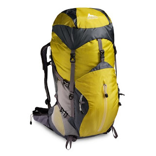
These are all great advantages. But these days, they are no longer exclusive to external frames. Many of the internal frames are now equipped with side pockets. Most will have advanced ventilation through a slight curvature of the frame. And pretty much every internal frame I've laid eyes on has several straps for tying on gear.

But for individuals unable to invest in that super, compressible sleeping bag, the external frame may still be the best choice. In order to cross over, one must be willing to make a few extra investments. The internal frame is just that. Internal. Ninety percent of the gear must go inside the pack. The massive, jelly-roll, 0 degree bag is not going to fit, nor will the 8 pound Coleman tent. These are choices one will face if they decide to go with an internal.

But are these investments worth it? After all, a decent synthetic or down sleeping bag could range anywhere from $100 to $250. And light and compact tents are not cheap either. Take it from someone who has been there. I made the crossover just a year ago, and it has been so worth it. I am able to hike faster, cover more ground, experience more on every trip, and I'm comfortable from the moment I put the pack on to the moment I take it off at the end of the day. And in my experience, the individuals who seem to most appreciate the comfort and support of internal frames are those who have only ever known the dependability (yet, discomfort) of externals, but finally went out on a limb and decided to give it a try.

Saturday, March 28, 2009

Boone Climbing Action Systems


November, 2008


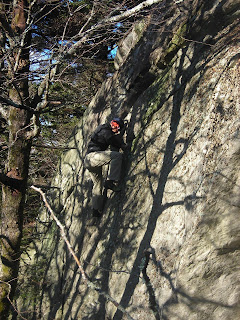
Team Blue Ridge came to visit, and we ventured to Boone for some rock climbing! It was my first time climbing on actual rock. I didn't do much, but these guys really know what they're doing!

My friend and former manager, Nicholas "The Legend" Orrell, coached me up this one crack, and I was doing okay, but then, out of nowhere, he says, "Okay, you should come down now." My legs are wobbling by this point, and I am totally exposed on this massive boulder (no ropes or safety equipment), so I respond, "And how do I do that?" To make a long story short, he coached me down, and I will climb with ropes next time! Looking forward to giving this another try in the future...


Percy is either out of his mind, or he's fearless; at least, he's a really skilled climber! (No Ropes!)


It was overcast most of the day, but we avoided the worst of the weather right up till the end. Suddenly, it was snowing, sleeting, and freezing cold! We had to hightail it outta there!

Suited up and ready to go!

Thursday, March 26, 2009

On the Summit


Kenny and I explore Table Rock... After such a strenuous hike, we are happy to be there! Somewhere near this point is where Chingachagook tells his adopted son, Hawk Eye, in "The Last of the Mohicans," that the white man will take this land from the Indians. He was right...

The Linville Gorge: North Carolina's Wilderness Frontier

March, 2009 ~ North Carolina

Kenny and I are in the Linville Gorge Wilderness, lumbering up the Little Table Rock Trail, and let me tell you: it's a doozy.

We have come to this pristine wilderness for an overnight backpacking venture across exposed ridges, rocky slopes, and precarious outcroppings; it is among North Carolina's greatest frontiers. Our journey begins near the base of Hawksbill Mountain. We heft our backpacks and embark down the Spence Ridge Trail. The Linville Gorge Wilderness, west of Morganton, NC, is host to numerous trails, offering plenty of opportunities for day hikes and multi-day backpacking endeavors. But, being a wilderness area, the trails are unmarked, so a map and a plan of attack are essential. Kenny and I take a left onto the Little Table Rock Trail. It is early on, and we feel fresh. We have no idea how steep it will soon become.

A mile later, we stagger onto the first rock outcropping, where we are presented with an impressive view of the gorge. The Linville River snakes through the basin below and is surrounded by steep, rock walls. We have an obscured vantage on Table Rock Mountain, our destination. After a bite to eat, we carry on and quickly intersect the Mountains to Sea Trail, which takes us to the Table Rock spur.

The steepness increases. We push on, feeling the burn in our hamstring and calf muscles. It seems the higher we climb, the heavier our packs weigh. Gravity tries its hardest to pull us down. But, at the same time, the mountain emboldens us. It beckons to be explored. It lures us with its solid presence. This mountain is powerful.

As we reach the top of Table Rock Mountain and see the magnificent Linville Gorge in its entirety, our exhaustion and frustration vanish. This view was worth it. In the distance, we see Lake James, where they filmed some pivotal scenes for the film, "The Last of the Mohicans." On a sunny day, it would surely shimmer, but today the skies are overcast. The anticipation of rain has hung over us since we began our trek, but it looks as if the hazy clouds on the horizon are going to miss us. We are deeply thankful.

We explore the summit of Table Rock, recognize another spot from Michael Mann's frontier epic, and shoulder our packs for the return journey. What we just came up, we must now go down. While going downhill is easier on one's respiratory system, it is far more strenuous on one's knee joints. As we descend the mountain, I feel a burning sensation in my knees, a nuisance I have had to deal with since my hiking injury in '07.

Eventually, we reconnect with the Spence Ridge Trail and turn left towards the Linville River. A mile later, we arrive at the bottom of the gorge. The water is deep, and class III rapids rage up river; water gushes over rocks, and strong currents sweep underneath the two wooden bridges that cross the river. They are narrow and single-railed, so Kenny and I maneuver over them carefully.

As we enjoy the lively sounds of the water, we are greeted by several college students, whom we first encountered on Table Rock. The leader of their pack carries an empty liquor bottle, and - words slightly slurred - tries his darndest to convince us to sleep in "that sweet cave over there!" He points downriver, and we kind of nod, giving them something to get excited about, and they go on their merry way. Kenny and I quickly decide against sleeping in the "death cave," as neither of us are keen on being eaten by a bear or drowned in a flash flood.

Later, we hike a quarter mile back up the trail, till we find a suitable campsite by a babbling brook. There, we take a load off and reflect on our exciting day. Kenny soaks his feet in the cold stream, and I snap some shots of the water cascading over mossy stones. Building a fire proves challenging, since most of the wood is damp, but we manage, somehow, to get a fine flame going, and we pass the evening in its warm glow.

We wake up the next morning at 5 am; Kenny has an engagement to attend in Greensboro at 10 o'clock. So we hike the last mile of our journey in the dark, led by the LED beam of my headlight. For Kenny, this is a trip of firsts - his first backpacking adventure, his first taste of "backpacking food," which is always delicious when you're starving, and his first hike in the dark. By its indiglo light, my watch reads 7 am when we reach the car. As we load our packs and prepare for the return voyage, we thank God for his grace upon us. We are tired, but energized. Dry and joyful. We have been to and from the mountains, and we will surely return, because we were made for the wild. But for now, it is time to go home.

Book Review: The Faith of Adventure


"The Incredible Story of a 25-Year-Old's Summit of Mt. Everest"


The Lyons Press
Copyright 2000
279 pgs.

An interesting black and white painting graces the title page of Bear Gryll's first non-fiction endeavor, "The Kid Who Climbed Everest." A mountaineer dangles over a seemingly bottomless crevasse, while his partner sits near the edge, coaching him across. In the bottom right corner, it says, "I lift my eyes up to the mountain - where does my help come from? My help comes from the Lord, maker of Heaven, Creator of the earth" (Psalm 121). It is a fitting intro, because it accurately foreshadows Gryll's novel from start to finish, as he consistently gives glory to whom glory is deserved - our Father in Heaven.

The book begins with Gryll's tragic parachuting accident over the skies of Africa. In 1996, Grylls, 23, was on a routine exercise for the British Army, but his chute failed to open, and his back all but shattered when he slammed into the desert floor. It was by the grace of God he survived. For months upon months, Grylls endured painful physical therapies and lived in hospitals. No one thought he would ever walk again. But Bear had a dream, kindled at a young age when his father gave him a photo of Mt. Everest. Bear saw his hopes and dreams fading, but through prayer and determination, he relearned to walk, and 18 months after his accident, he set foot on the summit of Everest, the tallest mountain in the world.

From here, Grylls recounts his tale in moderately good fashion. He is not a writer, rather, a personality, and this is what saves him. But this good ole' yarn is hard to put down, as he transcribes the excitement and chaos of base camp - full of Sherpa guides, cooks, and yaks - the harrowing climb up the Lhotse Face Icewall - always shifting, sometimes swallowing climbers without warning - and his near-death experiences, from falling 90 feet into a crevasse, to having serious altitude sickness and being at the mercy of his friends and Sherpa guides.

Throughout his book, Grylls quotes scripture and boldly acknowledges his dependence on God. He consistently prays for safety and even leads his team members in worship, citing lyrics from the song, Amazing Grace:

"Through many dangers, toils and snares I have already come, 'tis grace that brought me safe thus far and grace will bring me home."

During particularly difficult times, he would turn to a seashell his fiance had given him; in it, she had written, "Be sure of this, that I am with you always, even unto the end of the world" (Matthew 28:20), and this was his great comfort and source of strength.

Also in Gryll's book, readers will recognize sincere reverence for the natural world. His reflections on the mountains mirror his awe and love for the Creator. Grylls writes:

"[...] The draw of the mountains is their simplicity. That fierce force of nature, where the wind howls around you and you struggle for breath and life itself; it is strangely irresistible to man. The simple sound of ice beneath your crampons, crunching as the teeth bite into the frozen surface. The raw beauty of being so high and so remote, [seeing] the greatest mountain range in the world sprawled beneath you. All of it inexplicably draws us to them" (271).

While Grylls' adventure is the stuff of epic storytelling, the biggest draw to his book is the faith and perseverance he portrays up and down the summit. Plenty of people have climbed Everest. But not as many give the credit to God. Upon his return, he was repeatedly asked if he had found God on the mountain. His response...no. "You don't have to climb a big mountain to find a faith. [It] is the wonderful thing about God; He is always there, wherever you are" (272).

To anyone who is interested in reading about a man's struggles and his Father's helping hand, "The Kid Who Climbed Everest," would make a fine addition to the summer reading list.

Wednesday, March 25, 2009

Ascending Table Rock


March, 2009

Kenny and I reach the first overlook on our way up Little Table Rock Trail!

We stopped for lunch here and got our first preview of the Linville Gorge. At the end of the video, you will see a view of Hawksbill Mountain. Our hike began near the base of that peak. By this point, we have hiked roughly 3 miles... Not a lot, but very strenuous.

Tuesday, March 24, 2009

Kenneth the Conquerer & Sir Evan Summit Table Rock Mountain


This photo was taken from the top of Table Rock Mountain in the Linville Gorge Wilderness of western North Carolina. There are a couple ways to reach the summit, but I think Kenny and I chose the hardest, unknowingly. It wasn't a long hike, but it was literally straight up. We were pretty tired by this point, but the view was so worth all the hard work, and besides, hiking is one of those activities that is fun even when it's tough!

This is also where they filmed some scenes from "The Last of the Mohicans," so that was pretty awesome. We had some friendly (and inebriated) college students take our picture. They also tried to convince us to sleep inside a cave down by the river. I have several words about that. Bears and Flash Flooding.

A more detailed article is on its way!

Thursday, March 19, 2009

Enjoy A Game Of Risk?

My friend, Jim Ed, is a filmmaker. He's been hard at work on a feature length film for nearly two years now, and the premier at Richmond, Virginia's popular, old-time theater, "The Byrd," is steadily approaching. This is a film he made with some of his college friends that I've always enjoyed! It is creative and put together well. One of these days, we may very well see "A Film by Jim Ed Wills" as the credits roll...

This Will Give You Goosebumps

Wow! Came across this video earlier today. This has got to be the most dangerous hiking trail out there! Check it out!

Wednesday, March 18, 2009

St. Mary's River Trail


July, 2008


John and I hike along the St. Mary's River Trail and discover a cool swimming hole. As we are exploring, I realize I've been here before, years ago as a Boy Scout! Suddenly, the St. Mary's Wilderness is like an old friend.

Tuesday, March 17, 2009

John Martin & Sir Evan's Epic Adventure in the St. Mary's Wilderness


July, 2008


It is our first foray into wild territory. Armed only with a map and our wits about us, John Martin and I venture into St. Mary's Wilderness, a congested, rugged landscape without trail blazes or signs to lead the way. It is an intersection of narrow, barely recognizable trails, concealed behind lush vegetation, all of them insurmountably leading to the St. Mary's River Gorge below. It is Virginia's largest wilderness area, and it is begging to be explored!

We enter the wilderness.

On a humid day like this one, we are careful to stay hydrated, frequently drinking from our Nalgenes, occasionally nibbling on electrolyte fruit snacks. Our trekking poles scoop overgrown branches away from the path, but the ensuing whiplash strikes at our legs, and they are soon scratched and irritated.

We are here partly because John is convinced our friendship lacks credibility. "I wish we could be friends," he says, a typical statement I've come accustomed to hearing from him. I respond, as usual, "We are friends, John." But he insists we are not, and that we must embark on a quest together in order to make it so. This is what brings us to the wilderness.


We hike along the Mine Bank Creek Trail (at least we think so), stopping along the way to take a plunge in an inviting swimming hole. Later, we reach the Gorge and realize we shouldn't have stopped. The river is far more inviting. We're already wet, so we take another swim in a massive pool down river. There, we encounter a baby copperhead. I nearly step on it and barefoot! John also freaks out about a giant spider, and we are certain it's a Brown Recluse, but we are surely wrong, and it isn't even poisonous. So we carry on! But then disaster nearly strikes when I have a run in with a full-blown anaconda!

True story? You decide. If you look closely, you just might see it...

From here, our journey takes us along the St. Mary's River Trail. We cannot resist the temptation to veer off the trail, however, and explore the river bed. It is both scenic and refreshing, and as we reach a particular swimming hole and water fall, I realize I have been to this place before! Years ago as a Boy Scout. I am very excited! John doesn't care. He is too busy jumping off ledges and trying to splash me from far away.

After an afternoon of exploring and swimming, we must begin the arduous hike back to civilization. The heat dries our clothes as we traverse the rocky trail, making excellent time, thanks to our trekking poles and hunger. By the time we return to the cars, our lower halves are caked in mud, but we don't care. We had a blast, and our friendship is credible, once more!

Of course, John will continue to deny it for some time afterword, and we will probably have to engage in other legendary acts of derring do to prove yet again that we are, in fact, friends. But hey, if that's what gets us out there, then keep it up, John! We are not friends...


Stone Mountain: A Day on the Defiant Dome


February, 2009


Stone Mountain might be the most accurately named peak of them all: it is a white stone the size of a mountain. And it makes for a great day hike.

Emily and I are halfway to the summit of North Carolina's premier dome, a granite structure popular for its breathtaking views, cascading waterfalls, and challenging "friction climbing." We reach the first overlook, prefaced by a winding "stairway to heaven," guardrails included, that almost seems to take something from this pure land form, but is surely in place for our safety. From our perch, we gaze west towards Wolf and Cedar Rocks, other notable landmarks in Stone Mountain State Park. Located in Elkin County, just south of the Blue Ridge Parkway, the park is host to several hiking trails, three major waterfalls, and trout streams for those who hike with a fly rod. With opportunities for backpacking, as well, it is a prime mountain getaway.

After a bite to eat, we continue up the aptly named Stone Mountain Trail, and soon reach the summit. At 2,305 feet, this exposed slope offers quite a view of the surrounding landscape. Shallow indentions follow the gradual and seemingly smooth curvature of the mountain, undoubtedly left behind by countless rain slides. While it may appear, at a distance, smooth like a marble, Stone Mountain is scarred by fissures, grooves, and protrusions. Yet, for all erosion has done to this mountain, it has also made it the natural marvel it is today.

Emily, a trained photographer, captures some shots of roaming hawks and "the Hero Tree," a lone, wind-swept piece of bark jutting out of the rock face, before we head down the other side of the mountain.

After a steep descent we come across a sign warning of death near the 200 foot "Upper Falls," and we can hear rushing water plummeting over the mountainside. Like backyard explorers, we exchange excited glances and rush towards the source. An impressive,
labyrinthine staircase zigzags down the peak, taking hikers to the collecting pool at the bottom of the falls.

Emily and I stand within two yards of the pounding, frothy drink. A light spray tickles my face. If only it was summer... I would be swimming!

Later, we hike past the Hutchinson Homestead - a plot of land straight out of history - not to mention a spectacular view of Stone Mountain in its entirety. In the far distance, we see a rock climber ascending the Great Arch, a long, serpentine crack up the side of the dome, and testament to nature's eroding effects on the mountain.

As we return to the "lower" parking area and complete the Stone Mountain Loop, we are both impressed by what we've encountered and eager to come back, since we've really only scratched the surface. But something tells us we won't have to rush back. Like the Hero Tree, this mountain knows how to endure.

Proco Staffers in the Great Outdoors


"Climb the mountains and get their good tidings!" ~ John Muir

This is a video Emily and I recorded from the summit of Stone Mountain in Elkin County, NC. February, 2009.

Monday, March 16, 2009

Mount Rogers Backpacking Adventure... Blue Ridge Style!

This video was taken in July, 2008, at Grayson Highlands, VA. On this particular trip, my former coworkers from Blue Ridge Mountain Sports and I undertook a 12 mile traverse across rolling plains, rocky trails, and wilderness streams. Our destination: Mount Rogers, the tallest mountain in Virginia!


On our way, we encountered dozens of wild ponies, a notable trademark of Mount Rogers. One pony, in particular, grabbed our interest. Straight out of the 80's with his long, flowing mane, we dubbed him the Bon Jovi horse. Later, that pony would outsmart and humiliate us by reaching the top of the mountain first. How this majestic, four-legged beast of the wilderness managed to accomplish this, we never did learn...


After a desparate search for water (which ended well, thanks to a good Samaritan..."Dat map is wrong! The water be over dere!") we made camp and constructed the most epic camp fire in existence! But not before watching the sunset from Rhodedendron Gap...


After making it through a chilly night with little more than my survival blanket (it is surprisingly cold on the top of a mountain, even in July...) I awoke thirsty and craving hydration, as did my compatriots, so we left camp to purify water. Upon our return, we discovered our campsite invaded by wild ponies. Curious, backpack-sniffing, wild ponies.


Thank you, Mount Rogers, for an epic time in the foothills of Virginia.


Piedmont Vistas: Day Hiking in the Sauratown Mountains


Part II


Now that you've tackled Jomeokee, the Great Pilot, and seen the white cliffs standing silently over the Piedmont Plateau and the raptors soaring around Big Pinnacle, it is time to venture northeast to Hanging Rock State Park, home to Moore's Knob, Cooks Wall, and Hanging Rock, the tallest peaks in the Sauratown Mountain Range.

When I first moved to Winston-Salem, Hanging Rock fast became my initial impression of the North Carolina mountains. Since my first day hike there with friends, Erica and Sarah, I have returned several times to explore the different trails and witness the Piedmont's seasonal evolution. With trails of varying length and difficulty, plus plenty of opportunities for camping, it is the ideal park for family getaways.

The Hanging Rock Trail is easily accessed from the visitor center parking lot and is 2.2 miles, out and back. It is a steep and strenuous climb but well-maintained and worth the effort. In the summer, Hanging Rock is shrouded in haze. At 2,070 feet, even this jagged rock face cannot escape the southern humidity. But it was encouraging to find hikers scrambling up the trail, regardless! A lot can be said for a cool mountain breeze after a tiring ascent.

I returned in November, hoping to catch the sunset from Moore's Knob, where an impressive, stone observation tower looms above the tree line. Sitting at 2,579 feet, Moore's Knob is the tallest point in the Sauratown Mountains. The Moore's Wall Loop Trail can be found at the second parking lot, just beyond the visitor center. On their way up, visitors will witness outstanding rock structures, such as Indian Face and Balanced Rock. From the summit, hikers can see Hanging Rock to the east, and to the west, Pilot Mountain, a faint bump on the cusp of the horizon.

When my old college buddies, Sherwin, Matt, and Robbie, came to visit this past January, Hanging Rock State Park once again seemed a good place to explore. We embarked down the Cooks Wall Trail, encountering dozens of fellow hikers with their dogs and stopping on our way at House Rock, a flat ledge with views to the southeast, and Cooks Wall, a popular spot for climbers. Shortly after, we arrived at Devil's Chimney, where sunshine radiated through the clouds like the glow of Heaven. From this exposed rock face, Winston-Salem is visible on a clear day.

My most recent day hike in the Sauratown Mountains took me back to the summit of Hanging Rock, this time, with my good friend, Tim Bob. It was an especially frigid morning, and the parking lot was nearly deserted. From the summit, the Piedmont Plateau looked bare, radically different from its lush appearance in August. And rather than having to endure humidity, we were forced to take cover from cold mountain gusts strong enough to blow us over. Yet, despite the landscape's transformative nature, the Sauratown Mountains remain a testament to the strength of these lands and the power of nature and heritage. The seasons may come and go, but the mountains will always remain.

To see this article on the Great Outdoor Provision Co. Blog, in addition to other articles about the outdoor lifestyle, follow this link...

Piedmont Vistas: Day Hiking in the Sauratown Mountains


Part I

You've been itching to get outside all week; the weather has been unbelievable, and your hiking boots in the corner of your closet are collecting more dust than mountain dirt. You've got to go hiking! But time is precious, and there aren't enough hours in the day. The Appalachians are too far, you think. Maybe next weekend... Fortunately, for those in Winston-Salem and surrounding cities, Pilot Mountain and Hanging Rock State Parks are within close driving distance, so there's no excuse for delaying that day hike!

As a native of Virginia with a brief track record in North Carolina, I have much exploring still ahead of me; but so far, Pilot Mountain and Hanging Rock have provided several fun-filled days in the outdoors.

Pilot Mountain, located between Pinnacle and Mount Airy, NC, towers 2,421 feet tall. It is a giant monadnock amongst a heritage-rich landscape and part of the Sauratown Mountain Range. On a clear day, it can be seen miles away, incoming on Route 52 out of Winston. I first visited "Jomeokee," as the Saura Indians once called it, in October, 2008. While visitors are more than welcome to park at Little Pinnacle Overlook and forego the arduous climb, my friend Jennie and I attempted the Grindstone Trail, which takes hikers from the bottom up with a 500-foot plus elevation gain in under two miles. On this breezy October day, the trees were painted red, orange, and yellow, and as we neared the summit, the tree line thinned to reveal an expansive view of azure skies and vibrant countryside. Immense, white cliffs border the Ledge Spring Trail, which forms a loop with the Grindstone, taking hikers to the overlook. There, visitors are presented with a clear view of Big Pinnacle (Pilot Mountain), home to raptors and ravens.

Jomeokee Trail leads hikers down and around the knob-shaped mountain, but climbing the steep rock walls that make Pilot such a unique monolith is forbidden to ensure the survival of the birds inhabiting it. However, rock climbers frequent the aforementioned cliffs along Ledge Spring Trail. Jennie and I traversed the Jomeokee Trail, awed by Pilot's bold presence, and assailed by legions of lady bugs, a sign - I am told - of good fortune. And if my first visit to Pilot Mountain is any indication, you better believe I'll be back in the spring.

To see this article on the Great Outdoor Provision Co. website, among other articles, click this link...